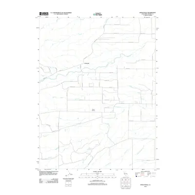
2012 Map of Henleyville
USGS Topo · Published 2012About this map
Henleyville sits at the center of this agricultural landscape in Tehama County, where the plains meet the rising drainages of the western Sacramento Valley. The settlement is defined by a grid of rural roads named for the region's orchards, including Almond Ave, Peach Ave, and Apple Rd, reflecting the long-standing horticultural economy of the area. A network of seasonal creeks, such as Thomes Cr and Jewett Cr, cuts through the terrain, originating from higher ground near Butte Mountain Rd and converging as they flow eastward. To the south, Squaw Hollow provides a distinct topographic landmark amidst the shifting elevation. For local historians, the presence of Freeman Schoolhouse Rd and Gutenberger Rd points to the family names and early civic institutions that once anchored these outlying farming communities.
Find a feature on this map
44 named features on this map. Tap any name to fly to it.
Don’t see what you’re looking for? This feature index may not catch every label — zoom into the map to look around manually.
Map Details
Editions of this 2012 Henleyville Map
This is the sole edition of this map. No revisions or reprints were ever made.
Other maps of this area

1890 · Red Bluff
USGS Topo · 1:250,000

1894 · Red Bluff
USGS Topo · 1:250,000

1904 · Vina
USGS Topo · 1:62,500

1905 · Tehama
USGS Topo · 1:62,500

1914 · Kirkwood
USGS Topo · 1:31,680

1944 · Flournoy
USGS Topo · 1:62,500
1949 · Kirkwood
USGS Topo · 1:24,000
1950 · Kirkwood
USGS Topo · 1:24,000

1950 · Gerber
USGS Topo · 1:24,000

1951 · Gerber
USGS Topo · 1:24,000