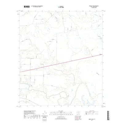
2019 Map of Hensley Lake
USGS Topo · Published 2019About this map
The San Antonio River meanders through the southern portion of this Goliad County landscape, defining a riparian corridor marked by oxbows and creek confluences. Just north of the river, Hensley Lake and the drainage of Cadena Cr sit amidst a network of rural roads and established property lines. The settlement of Fannin occupies the eastern edge of the quadrangle, serving as a focal point for local history near the Fannin Cem. This area is characterized by a complex hydrographic system where numerous tributaries, including Manahuilla Cr, Alligator Cr, and Dry Cr, carve through the terrain toward the primary river valley. Genealogists and local historians can find significant landmarks such as the Sepenter Cem and follow the paths of named local routes like Old Fannin Rd and Goliad N which crisscross the ranchlands and agricultural fields of South Texas.
Find a feature on this map
51 named features on this map. Tap any name to fly to it.
Don’t see what you’re looking for? This feature index may not catch every label — zoom into the map to look around manually.
Map Details
Editions of this 2019 Hensley Lake Map
This is the sole edition of this map. No revisions or reprints were ever made.
Other maps of this area

1953 · Beeville
USGS Topo · 1:250,000

1956 · Beeville
USGS Topo · 1:250,000

1960 · Beeville
USGS Topo · 1:250,000
1962 · Live Oak Lake
USGS Topo · 1:24,000
1962 · Fannin
USGS Topo · 1:24,000
1962 · Lott Lake
USGS Topo · 1:24,000
1962 · Melo
USGS Topo · 1:24,000
1962 · Hensley Lake
USGS Topo · 1:24,000
1962 · Goliad
USGS Topo · 1:24,000
1963 · Weesatche
USGS Topo · 1:24,000