
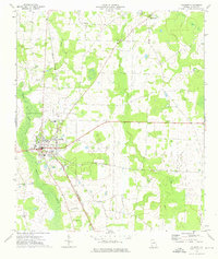
1973 Map of Hentown
USGS Topo · Published 1975About this map
Hentown and the smaller settlement of Cuba anchor this rural landscape in the early 1970s, where agricultural life is defined by the winding paths of Spring Creek and Dry Creek. The map reveals a high density of community centers, particularly small rural churches such as Macedonia Ch, St Johns Ch, and St Marys Ch. These religious landmarks, often paired with family or community burial grounds like Bush Cem and Dubose Cem, provide vital geographic markers for genealogists tracing southwest Georgia roots. The terrain is characterized by a network of drainage features including Wamble Creek, Lime Branch, and Blue Creek, while a Landing Strip and a Radio Tower mark the mid-century modernization of the Early County countryside.
Find a feature on this map
25 named features on this map. Tap any name to fly to it.
Don’t see what you’re looking for? This feature index may not catch every label — zoom into the map to look around manually.
Map Details
Editions of this 1973 Hentown Map
This is the sole edition of this map. No revisions or reprints were ever made.
Other maps of this area

1953 · Dothan
USGS Topo · 1:250,000

1954 · Dothan
USGS Topo · 1:250,000

1955 · Dothan
USGS Topo · 1:250,000

1973 · Blakely North
USGS Topo · 1:24,000

1973 · Bancroft
USGS Topo · 1:24,000

1973 · Blakely South
USGS Topo · 1:24,000

1974 · Donalsonville NE
USGS Topo · 1:24,000

1974 · Damascus
USGS Topo · 1:24,000

1974 · Arlington
USGS Topo · 1:24,000
1974 · Colquitt
USGS Topo · 1:24,000