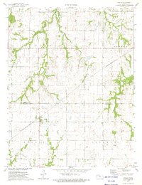
1973 Map of Hepler
USGS Topo · Published 1975About this map
Hepler and the surrounding borderlands of Bourbon and Crawford Counties are defined by the intersection of rail transport and rural agricultural life in the early 1970s. The Missouri - Kansas - Texas railroad cuts diagonally across the landscape, serving as a primary corridor through the townships of Walnut, Pawnee, and Sherman. The terrain is etched by the drainage systems of Walnut Creek, Paint Creek, and Pawnee Creek, which create pockets of woodland amidst the gridded section lines. A small cluster of activity is visible at Stephen, while scattered Oil Wells in the southeastern corner suggest local resource extraction. For genealogists, the map preserves the locations of rural burial grounds like St Mary Cem and Hiattville Cem, along with an unnamed cemetery near the rail line north of Hepler.
Find a feature on this map
17 named features on this map. Tap any name to fly to it.
Don’t see what you’re looking for? This feature index may not catch every label — zoom into the map to look around manually.
Map Details
Editions of this 1973 Hepler Map
This is the sole edition of this map. No revisions or reprints were ever made.
Other maps of this area

1884 · Fort Scott
USGS Topo · 1:125,000

1886 · Iola
USGS Topo · 1:125,000

1886 · Fort Scott
USGS Topo · 1:125,000

1893 · Fort Scott
USGS Topo · 1:125,000

1893 · Iola
USGS Topo · 1:125,000

1904 · Iola
USGS Topo · 1:125,000

1947 · Joplin
USGS Topo · 1:250,000

1948 · Erie
USGS Topo · 1:62,500

1948 · Girard
USGS Topo · 1:62,500

1949 · Erie
USGS Topo · 1:62,500