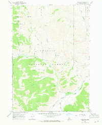
1967 Map of Herd Peak
USGS Topo · Published 1971About this map
Herd Peak dominates the northern reaches of this Idaho wilderness, marking a high point where the Sawtooth National Forest and Challis National Forest converge. The landscape is defined by its intricate drainage systems, most notably the North Fork Big Lost River which winds through the southern portion of the quadrangle. This mid-1960s survey illustrates a remote mountain environment primarily accessed by a network of specialized routes, including Pack Trails and Jeep Trails that navigate the steep elevations between Jim Canyon and Summit Creek.
Find a feature on this map
25 named features on this map. Tap any name to fly to it.
Don’t see what you’re looking for? This feature index may not catch every label — zoom into the map to look around manually.
Map Details
Editions of this 1967 Herd Peak Map
This is the sole edition of this map. No revisions or reprints were ever made.
Other maps of this area

1895 · Hailey
USGS Topo · 1:125,000

1897 · Hailey
USGS Topo · 1:125,000

1929 · Bayhorse
USGS Topo · 1:125,000

1955 · Hailey
USGS Topo · 1:250,000

1957 · Challis
USGS Topo · 1:250,000

1959 · Hailey
USGS Topo · 1:250,000

1960 · Challis
USGS Topo · 1:250,000

1962 · Hailey
USGS Topo · 1:250,000

1963 · Challis
USGS Topo · 1:250,000
1963 · Bowery Peak
USGS Topo · 1:24,000