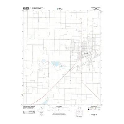
2010 Map of Hereford
USGS Topo · Published 2010About this map
Hereford dominates this High Plains landscape, situated along the meandering path of Tierra Blanca Creek. The town's layout reflects a rigid grid system common to the Texas Panhandle, interrupted only by the creek and the diagonal paths of major transit corridors. Local history is anchored at sites like West Park Cemetery and Rest Lawn Cemetery, providing critical touchpoints for genealogical research. The surrounding terrain is heavily defined by agricultural infrastructure, with a dense network of county roads such as Grenada Rd and Tierra Blanca Rd that partition the land into expansive rectangular tracts. State-maintained routes like FM 2856 and FM 1259 connect the central hub to the outlying rural reaches, illustrating the region's reliance on organized road systems for its ranching and farming economy.
Find a feature on this map
29 named features on this map. Tap any name to fly to it.
Don’t see what you’re looking for? This feature index may not catch every label — zoom into the map to look around manually.
Map Details
Editions of this 2010 Hereford Map
This is the sole edition of this map. No revisions or reprints were ever made.
Other maps of this area

1954 · Clovis
USGS Topo · 1:250,000

1958 · Clovis
USGS Topo · 1:250,000

1966 · Jumbo
USGS Topo · 1:24,000

1966 · Easter
USGS Topo · 1:24,000

1966 · Summerfield
USGS Topo · 1:24,000

1970 · Hereford
USGS Topo · 1:24,000

1971 · Westway
USGS Topo · 1:24,000

1971 · Hereford NE
USGS Topo · 1:24,000
1971 · Milo Center
USGS Topo · 1:24,000

1971 · Hereford SE
USGS Topo · 1:24,000