
1971 Map of Hereford NE
USGS Topo · Published 1973About this map
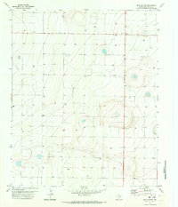
Deep within the Texas Panhandle, this early 1970s survey captures the industrial and agricultural character of the High Plains. The Atchison Topeka and Santa Fe railroad cuts across the southeast corner, serving as a vital artery for the region's ranching and farming economy. The landscape is defined by its water management and infrastructure, with numerous wells scattered across the terrain to tap into the underlying aquifer. Transportation and utility networks are clearly delineated, including the straight path of Progressive Road and a major Pipeline that traverses the quadrangle. A remote Landing Strip and an electrical Substa highlight the distributed nature of local infrastructure in this part of Deaf Smith County, reflecting a period of intensive land use and technological integration in rural Texas.
Find a feature on this map
6 named features on this map. Tap any name to fly to it.
Don’t see what you’re looking for? This feature index may not catch every label — zoom into the map to look around manually.
Map Details
Editions of this 1971 Hereford NE Map
This is the sole edition of this map. No revisions or reprints were ever made.
Other maps of this area

1954 · Tucumcari
USGS Topo · 1:250,000

1954 · Clovis
USGS Topo · 1:250,000

1958 · Clovis
USGS Topo · 1:250,000

1958 · Tucumcari
USGS Topo · 1:250,000

1961 · Buffalo Lake
USGS Topo · 1:62,500

1962 · Wildorado
USGS Topo · 1:62,500

1965 · Allison Ranch
USGS Topo · 1:24,000

1966 · Ford
USGS Topo · 1:24,000

1970 · Hereford
USGS Topo · 1:24,000
1971 · Milo Center
USGS Topo · 1:24,000