
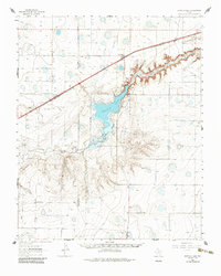
1961 Map of Buffalo Lake
USGS Topo · Published 1964About this map
Buffalo Lake and its surrounding High Plains terrain dominate this early 1960s survey, illustrating a landscape defined by water management and ranching. The Buffalo Lake National Wildlife Refuge follows the winding course of Tierra Blanca Creek, which cuts a distinct canyon through the flat Panhandle topography. Settlement is concentrated along the Panhandle and Santa Fe railroad line, where the small communities of Umbarger and Dawn serve as local hubs. Genealogists and historians can locate St Mary Cem near Umbarger and the Jowell Sch to the southeast, alongside several named agricultural operations like the Flying Mare Ranch and Happy Hereford Ranch. The map also meticulously records the infrastructure of the era, from the Bismark Road to a network of essential water sources such as the Cottonwood Windmill and Schoolhouse Windmill.
Find a feature on this map
27 named features on this map. Tap any name to fly to it.
Don’t see what you’re looking for? This feature index may not catch every label — zoom into the map to look around manually.
Map Details
Editions of this 1961 Buffalo Lake Map
2 editions found
Other maps of this area

1954 · Tucumcari
USGS Topo · 1:250,000

1954 · Amarillo
USGS Topo · 1:250,000

1954 · Plainview
USGS Topo · 1:250,000

1954 · Clovis
USGS Topo · 1:250,000

1958 · Clovis
USGS Topo · 1:250,000

1958 · Amarillo
USGS Topo · 1:250,000

1958 · Tucumcari
USGS Topo · 1:250,000

1958 · Plainview
USGS Topo · 1:250,000

1960 · Canyon
USGS Topo · 1:62,500
1960 · Buffalo Stadium
USGS Topo · 1:24,000