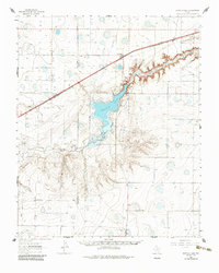
1961 Map of Buffalo Lake
USGS Topo · Published 1985About this map
Buffalo Lake and its surrounding wildlife refuge dominate the center of this Texas Panhandle landscape, where the waters of Tierra Blanca Creek cut a deep canyon through the High Plains. During the early 1960s, this area was a critical stopover for migratory birds within the Buffalo Lake National Wildlife Refuge. The map reveals a transition from the agricultural tablelands of Deaf Smith and Randall Counties to the complex drainage systems of the eastern edge.
Find a feature on this map
21 named features on this map. Tap any name to fly to it.
Don’t see what you’re looking for? This feature index may not catch every label — zoom into the map to look around manually.
Map Details
Editions of this 1961 Buffalo Lake Map
2 editions found

Other maps of this area

1954 · Tucumcari
USGS Topo · 1:250,000

1954 · Amarillo
USGS Topo · 1:250,000

1954 · Plainview
USGS Topo · 1:250,000

1954 · Clovis
USGS Topo · 1:250,000

1958 · Clovis
USGS Topo · 1:250,000

1958 · Amarillo
USGS Topo · 1:250,000

1958 · Tucumcari
USGS Topo · 1:250,000

1958 · Plainview
USGS Topo · 1:250,000

1960 · Canyon
USGS Topo · 1:62,500
1960 · Buffalo Stadium
USGS Topo · 1:24,000