
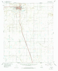
1960 Map of Canyon
USGS Topo · Published 1961About this map
West Texas State College serves as the focal point for the city of Canyon, marking a period of academic and urban growth on the High Plains. The landscape is defined by the convergence of Palo Duro Creek and Tierra Blanca Creek, where the natural drainage begins to carve the distinctive topography leading toward the Panhandle canyons. The Panhandle and Santa Fe railroad bisects the region, connecting the primary town site with smaller rail stops and rural communities like Cleta and Ogg. Outside the city limits, the terrain is dotted with Numerous quarries and water management features such as the Canyon Pumping Sta and McSpadden Lake. Genealogists may find interest in the documented locations of Dreamland Cem and Saint Paul Cem, while the inclusion of the Drive-in Theater and Conner Park reflects the mid-century social life of Randall County.
Find a feature on this map
33 named features on this map. Tap any name to fly to it.
Don’t see what you’re looking for? This feature index may not catch every label — zoom into the map to look around manually.
Map Details
Editions of this 1960 Canyon Map
2 editions found
Other maps of this area

1954 · Tucumcari
USGS Topo · 1:250,000

1954 · Amarillo
USGS Topo · 1:250,000

1954 · Plainview
USGS Topo · 1:250,000

1954 · Clovis
USGS Topo · 1:250,000

1956 · Fortress Cliff
USGS Topo · 1:24,000

1956 · Thomas Ranch
USGS Topo · 1:24,000

1958 · Clovis
USGS Topo · 1:250,000

1958 · Amarillo
USGS Topo · 1:250,000

1958 · Tucumcari
USGS Topo · 1:250,000

1958 · Plainview
USGS Topo · 1:250,000