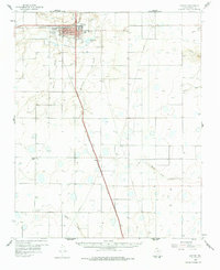
1960 Map of Canyon
USGS Topo · Published 1978About this map
West Texas State College serves as a major hub for this Panhandle community, situated at the confluence of Palo Duro Creek and Tierra Blanca Creek. The 1960 field check reveals a landscape transitioning between the urban growth of Canyon and the expansive ranch and farm lands of Randall County. The Panhandle and Santa Fe railroad corridor anchors the regional economy, running alongside the town’s grid and passing through the smaller settlement of Ogg.
Find a feature on this map
39 named features on this map. Tap any name to fly to it.
Don’t see what you’re looking for? This feature index may not catch every label — zoom into the map to look around manually.
Map Details
Editions of this 1960 Canyon Map
2 editions found

Other maps of this area

1954 · Tucumcari
USGS Topo · 1:250,000

1954 · Amarillo
USGS Topo · 1:250,000

1954 · Plainview
USGS Topo · 1:250,000

1954 · Clovis
USGS Topo · 1:250,000

1956 · Fortress Cliff
USGS Topo · 1:24,000

1956 · Thomas Ranch
USGS Topo · 1:24,000

1958 · Clovis
USGS Topo · 1:250,000

1958 · Amarillo
USGS Topo · 1:250,000

1958 · Tucumcari
USGS Topo · 1:250,000

1958 · Plainview
USGS Topo · 1:250,000