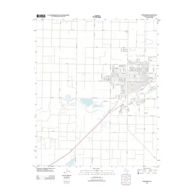
2012 Map of Hereford
USGS Topo · Published 2012About this map
Tierra Blanca Rd and a strict grid of county roads define this High Plains landscape in Deaf Smith County, centered on the expansion of Hereford. The 2012 layout shows the city's residential growth north of the winding Tierra Blanca Cr, where established neighborhoods include streets like La Plata St and Cherokee Dr. This era of the city's history is marked by a clear transition from the densely packed urban core to the industrial and agricultural outskirts, where names like Deere Dr hint at the local economy. On the northern and western fringes of the settlement, Rest Lawn Cem and W Park Cem serve as important landmarks for genealogical research, anchoring the modern map to the community's long-standing residents.
Find a feature on this map
119 named features on this map. Tap any name to fly to it.
Don’t see what you’re looking for? This feature index may not catch every label — zoom into the map to look around manually.
Map Details
Editions of this 2012 Hereford Map
This is the sole edition of this map. No revisions or reprints were ever made.
Other maps of this area

1954 · Clovis
USGS Topo · 1:250,000

1958 · Clovis
USGS Topo · 1:250,000

1966 · Jumbo
USGS Topo · 1:24,000

1966 · Easter
USGS Topo · 1:24,000

1966 · Summerfield
USGS Topo · 1:24,000

1970 · Hereford
USGS Topo · 1:24,000

1971 · Westway
USGS Topo · 1:24,000

1971 · Hereford NE
USGS Topo · 1:24,000
1971 · Milo Center
USGS Topo · 1:24,000

1971 · Hereford SE
USGS Topo · 1:24,000