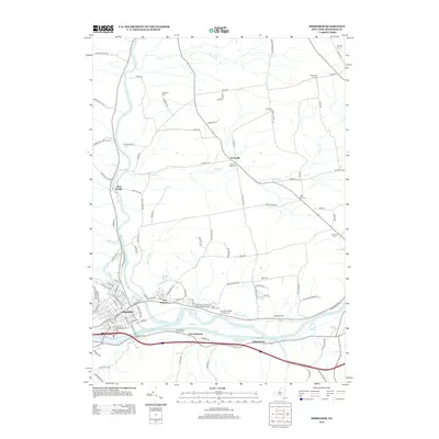
2013 Map of Herkimer
USGS Topo · Published 2013About this map
The Mohawk River corridor and the historic Erie Canal define the southern landscape of this New York quadrangle. Industrial and residential clusters concentrate in Herkimer and East Herkimer, while the surrounding terrain is marked by a network of rural roads such as Hard Scrabble Rd and Top Notch Rd. To the north, small settlements like Kast Bridge and Eatonville sit near the winding course of West Canada Cr.
Find a feature on this map
107 named features on this map. Tap any name to fly to it.
Don’t see what you’re looking for? This feature index may not catch every label — zoom into the map to look around manually.
Map Details
Editions of this 2013 Herkimer Map
This is the sole edition of this map. No revisions or reprints were ever made.
Other maps of this area

1898 · Utica
USGS Topo · 1:62,500

1900 · Little Falls
USGS Topo · 1:62,500

1900 · Utica
USGS Topo · 1:62,500

1903 · Richfield Springs
USGS Topo · 1:62,500

1903 · Little Falls
USGS Topo · 1:62,500

1907 · Winfield
USGS Topo · 1:62,500

1939 · Little Falls
USGS Topo · 1:62,500

1943 · Newport
USGS Topo · 1:24,000

1943 · Jordanville
USGS Topo · 1:24,000
1943 · Herkimer
USGS Topo · 1:24,000