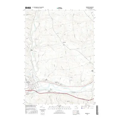
2016 Map of Herkimer
USGS Topo · Published 2016About this map
Fort Herkimer serves as a historical anchor for this portion of the Mohawk Valley, situated south of the Mohawk River near the modern Erie Canal. The landscape is defined by the convergence of the West Canada Creek with the Mohawk, a junction that historically dictated the placement of early settlements like Herkimer and Kast Bridge. High ground such as Schrader Hill and Shoemaker Hill flank the river valley, while smaller waterways like Stony Cr and Beaver Brook drain the surrounding uplands. Genealogy researchers will find significant value in the dense cluster of religious and family burial sites, including the Saints Peter And Paul Russian Orthodox Cem, Holy Spirit Polish Catholic Cem, and the historic Fort Herkimer Church Cem. The distribution of these sites reflects the diverse immigrant heritage and long-standing family lineages that shaped the Mohawk and East Herkimer communities.
Find a feature on this map
99 named features on this map. Tap any name to fly to it.
Don’t see what you’re looking for? This feature index may not catch every label — zoom into the map to look around manually.
Map Details
Editions of this 2016 Herkimer Map
This is the sole edition of this map. No revisions or reprints were ever made.
Other maps of this area

1898 · Utica
USGS Topo · 1:62,500

1900 · Little Falls
USGS Topo · 1:62,500

1900 · Utica
USGS Topo · 1:62,500

1903 · Richfield Springs
USGS Topo · 1:62,500

1903 · Little Falls
USGS Topo · 1:62,500

1907 · Winfield
USGS Topo · 1:62,500

1939 · Little Falls
USGS Topo · 1:62,500

1943 · Newport
USGS Topo · 1:24,000

1943 · Jordanville
USGS Topo · 1:24,000
1943 · Herkimer
USGS Topo · 1:24,000