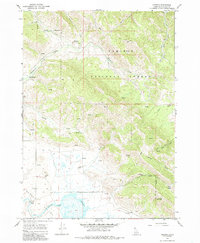
1966 Map of Herman
USGS Topo · Published 1985About this map
Herman sits at the edge of the wetlands where the rugged foothills of the Caribou National Forest meet the expanse of Grays Lake. This 1960s survey documents a landscape defined by water management and high-altitude forest service infrastructure, notably the Brockman (Guard Station) positioned along Brockman Creek. The map reveals the hydrology of the Idaho high country, from the northern Hot Spring and numerous unnamed springs to the southern Outlet and the Gaging Station monitoring the lake levels. In the lower terrain, man-made features like Storage Bins, a Cinder Pit, and various wells suggest a localized rural economy centered on ranching or basic extraction, while higher elevations are crossed by a network of Pack Trails and Jeep Trails through basins like Della Basin and along drainage points like Pote Creek and Clear Creek.
Find a feature on this map
26 named features on this map. Tap any name to fly to it.
Don’t see what you’re looking for? This feature index may not catch every label — zoom into the map to look around manually.
Map Details
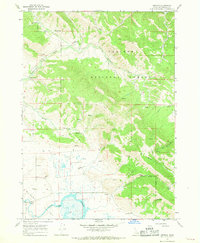
Editions of this 1966 Herman Map
2 editions found
Other maps of this area

1917 · Cranes Flat
USGS Topo · 1:62,500

1924 · Hell Creek
USGS Topo · 1:62,500

1926 · Hell Creek
USGS Topo · 1:62,500

1932 · Irwin
USGS Topo · 1:96,000

1935 · Irwin
USGS Topo · 1:125,000

1955 · Driggs
USGS Topo · 1:250,000

1958 · Driggs
USGS Topo · 1:250,000

1962 · Driggs
USGS Topo · 1:250,000
1966 · Bear Island
USGS Topo · 1:24,000

1966 · Big Elk Mtn
USGS Topo · 1:24,000