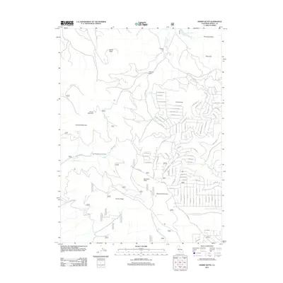
2012 Map of Hermit Butte
USGS Topo · Published 2012About this map
Hermit Butte and Manzanita Mountain dominate this landscape in the northern California high country. This survey illustrates a network of mountain roads and trails, many bearing names that hint at the region’s pioneering and ranching past, such as Stallion Rd, Oxen Rd, and Whiskey Flat Trl. Water is a defining element of the geography, with numerous named sources like Kelly Spring, Jackson Cabin Spring, and Doe Spring feeding the drainage basins of Rush Creek and Toms Creek. The presence of the Upper Rush Creek Campground and Big Lakes Camp suggests a modern landscape primarily utilized for recreation and resource management. Local history researchers can trace the detailed placement of these springs and the specific paths of minor waterways like Cottonwood Creek and Fitzhugh Creek as they navigated the volcanic terrain of Manzanita Ridge and Hunters Ridge.
Find a feature on this map
120 named features on this map. Tap any name to fly to it.
Don’t see what you’re looking for? This feature index may not catch every label — zoom into the map to look around manually.
Map Details
Editions of this 2012 Hermit Butte Map
This is the sole edition of this map. No revisions or reprints were ever made.
Other maps of this area

1886 · Alturas
USGS Topo · 1:250,000

1892 · Alturas
USGS Topo · 1:250,000

1954 · Alturas
USGS Topo · 1:250,000

1958 · Alturas
USGS Topo · 1:250,000

1961 · Canby
USGS Topo · 1:62,500

1961 · Alturas
USGS Topo · 1:62,500

1962 · Alturas
USGS Topo · 1:250,000
1962 · Adin
USGS Topo · 1:62,500

1962 · Likely
USGS Topo · 1:62,500

1965 · Alturas
USGS Topo · 1:250,000