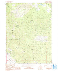
1990 Map of Hermit Butte
USGS Topo · Published 1990About this map
Modoc National Forest dominates this high-country landscape, defined by a series of prominent peaks and high ridges in the Warner Mountains region. The terrain is marked by notable elevations such as Grouse Mountain, Hermit Butte, and Horsehead Mountain, which overlook a complex network of canyons and gulches. Evidence of forest management and recreational use is visible at the Upper Rush Creek Campground and the Manzanita Lookout station atop Manzanita Mountain.
Find a feature on this map
42 named features on this map. Tap any name to fly to it.
Don’t see what you’re looking for? This feature index may not catch every label — zoom into the map to look around manually.
Map Details
Editions of this 1990 Hermit Butte Map
This is the sole edition of this map. No revisions or reprints were ever made.
Other maps of this area

1886 · Alturas
USGS Topo · 1:250,000

1892 · Alturas
USGS Topo · 1:250,000

1954 · Alturas
USGS Topo · 1:250,000

1958 · Alturas
USGS Topo · 1:250,000

1961 · Canby
USGS Topo · 1:62,500

1961 · Alturas
USGS Topo · 1:62,500

1962 · Alturas
USGS Topo · 1:250,000
1962 · Adin
USGS Topo · 1:62,500

1962 · Likely
USGS Topo · 1:62,500

1965 · Alturas
USGS Topo · 1:250,000