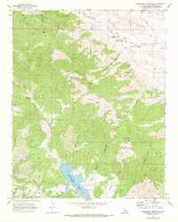
1969 Map of Hernandez Reservoir
USGS Topo · Published 1973About this map
Hernandez Reservoir and its surrounding canyonlands dominate this 1960s survey, illustrating a remote landscape shaped by water management and mineral extraction. The reservoir's high-water mark, noted by a Spillway Elev 2394, sits at the confluence of the San Benito River and Laguna Cr. Traceable human presence is sparse, marked by isolated outposts such as The Adobe and Harrison Cabin, alongside a network of rugged jeep trails and named springs like Bucks Peak Spring and Red Corral Spring.
Find a feature on this map
51 named features on this map. Tap any name to fly to it.
Don’t see what you’re looking for? This feature index may not catch every label — zoom into the map to look around manually.
Map Details
Editions of this 1969 Hernandez Reservoir Map
This is the sole edition of this map. No revisions or reprints were ever made.
Other maps of this area

1913 · Panoche
USGS Topo · 1:125,000

1915 · Priest Valley
USGS Topo · 1:125,000

1943 · New Idria
USGS Topo · 1:62,500

1943 · Hernandez Valley
USGS Topo · 1:62,500

1944 · Hernandez Valley
USGS Topo · 1:62,500

1944 · Panoche Valley
USGS Topo · 1:62,500

1948 · Santa Cruz
USGS Topo · 1:250,000

1955 · Santa Cruz
USGS Topo · 1:250,000
1956 · New Idria
USGS Topo · 1:62,500
1956 · Tumey Hills
USGS Topo · 1:24,000