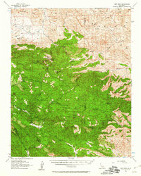
1956 Map of New Idria
USGS Topo · Published 1956About this map
New Idria (Idria PO) serves as the central hub of this mid-century survey, a remote mining enclave tucked into the high ridges of the Diablo Range. The landscape is defined by an intensive concentration of mineral extraction sites, including the San Carlos Mine, Aurora Mine, and the Picacho Mine. These operations are clustered around prominent peaks like San Benito Mtn and Sampson Peak, connected by a network of unimproved roads and a Landing Strip at Ashurst Ranch. To the east, the terrain breaks into the dramatic drainage of Cantua Creek and the long spine of Joaquin Ridge. The presence of the Jade Mill and numerous prospects near Clear Creek illustrates the specialized geological focus of the region during this era. Scattered water sources such as Spanish Lake and Rucker Spr provided essential relief in this high-elevation terrain between Vallecitos and the southern Tumey Hills.
Find a feature on this map
89 named features on this map. Tap any name to fly to it.
Don’t see what you’re looking for? This feature index may not catch every label — zoom into the map to look around manually.
Map Details
Editions of this 1956 New Idria Map
3 editions found
Other maps of this area

1912 · Coalinga
USGS Topo · 1:125,000

1913 · Panoche
USGS Topo · 1:125,000

1915 · Priest Valley
USGS Topo · 1:125,000

1923 · Levis
USGS Topo · 1:31,680

1923 · Monocline Ridge
USGS Topo · 1:31,680

1941 · Priest Valley
USGS Topo · 1:62,500

1941 · San Ardo
USGS Topo · 1:62,500

1943 · New Idria
USGS Topo · 1:62,500

1943 · Joaquin Rocks
USGS Topo · 1:62,500

1943 · San Ardo
USGS Topo · 1:62,500