
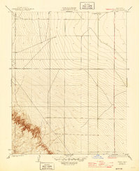
1923 Map of Levis
USGS Topo · Published 1923About this map
Levis serves as a focal point for this 1920s-era landscape, where the flatlands of the San Joaquin Valley meet the rising terrain of Monocline Ridge. The industrial footprint of early California petroleum development is evident at the Oil Pumping Sta, reflecting the importance of fuel infrastructure in Fresno County during the early twentieth century. Across the central plains, surveying lines and secondary routes connect local holdings like Englebrecht Ranch to the broader regional grid. The topography here transition from the orderly township and range divisions of the valley floor into the more complex, eroded contours of the western hills, illustrating the intersection of large-scale agriculture and the burgeoning oil industry of the time.
Find a feature on this map
7 named features on this map. Tap any name to fly to it.
Don’t see what you’re looking for? This feature index may not catch every label — zoom into the map to look around manually.
Map Details
Editions of this 1923 Levis Map
2 editions found
Other maps of this area

1912 · Coalinga
USGS Topo · 1:125,000

1913 · Panoche
USGS Topo · 1:125,000

1915 · Priest Valley
USGS Topo · 1:125,000

1922 · Tufts Ranch
USGS Topo · 1:31,680

1922 · Chaney Ranch
USGS Topo · 1:31,680

1923 · Englebrecht Ranch
USGS Topo · 1:31,680

1923 · Monocline Ridge
USGS Topo · 1:31,680

1924 · Tranquillity
USGS Topo · 1:31,680

1931 · Mouth of Cantua Creek
USGS Topo · 1:31,680

1943 · New Idria
USGS Topo · 1:62,500