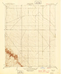
1923 Map of Levis
USGS Topo · Published 1945About this map
The small settlement of Levis and the nearby Oil Pumping Sta anchor this 1920s-era map of the Fresno County landscape. The terrain is defined by the sharp transition from the flat agricultural basins to the rising slopes of Monocline Ridge, where topographic lines reveal the complex drainage patterns of the Central Valley's western edge. Surveyed just after the Great War, the map documents a moment when early petroleum infrastructure began to appear alongside the traditional ranching lands of the San Joaquin Valley. The sparse distribution of man-made structures highlights the isolated nature of the pumping station and the small community at Levis, providing a precise record of industrial footprint and road networks before modern development reshaped the valley floor.
Find a feature on this map
3 named features on this map. Tap any name to fly to it.
Don’t see what you’re looking for? This feature index may not catch every label — zoom into the map to look around manually.
Map Details
Editions of this 1923 Levis Map
2 editions found
Other maps of this area

1912 · Coalinga
USGS Topo · 1:125,000

1913 · Panoche
USGS Topo · 1:125,000

1915 · Priest Valley
USGS Topo · 1:125,000

1922 · Tufts Ranch
USGS Topo · 1:31,680

1922 · Chaney Ranch
USGS Topo · 1:31,680

1923 · Levis
USGS Topo · 1:31,680

1923 · Englebrecht Ranch
USGS Topo · 1:31,680

1923 · Monocline Ridge
USGS Topo · 1:31,680

1924 · Tranquillity
USGS Topo · 1:31,680

1931 · Mouth of Cantua Creek
USGS Topo · 1:31,680