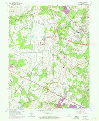
1966 Map of Herndon
USGS Topo · Published 1971About this map
Dulles International Airport dominates the western half of this Northern Virginia landscape, with its expansive runways and parking infrastructure cutting across the headwaters of Horsepen Run and Cub Run. East of the airport, the suburban transition is visible in the growth of Sterling Park and the established streets of Herndon. Historical layers remain evident at the Sully Plantation and the smaller community of Sully, positioned near the path of the Dulles Airport Access Road. The W & Od RR line passes through the heart of the area, connecting several small settlements and crossroads like Hatton Town, Floris, and Chantilly. Near the center of the sheet, the National Bureau of Standards operates its Sterling Radio Laboratory, signifying the region's increasing importance to federal technical operations during the mid-century.
Find a feature on this map
65 named features on this map. Tap any name to fly to it.
Don’t see what you’re looking for? This feature index may not catch every label — zoom into the map to look around manually.
Map Details
Editions of this 1966 Herndon Map
4 editions found
Other maps of this area

1884 · Harpers Ferry
USGS Topo · 1:125,000

1890 · Mt. Vernon
USGS Topo · 1:125,000

1891 · Harpers Ferry
USGS Topo · 1:125,000

1891 · Mt. Vernon
USGS Topo · 1:125,000

1893 · Frederick
USGS Topo · 1:125,000

1893 · Harpers Ferry
USGS Topo · 1:125,000

1894 · Warrenton
USGS Topo · 1:125,000

1894 · Frederick
USGS Topo · 1:125,000

1894 · Mt. Vernon
USGS Topo · 1:125,000

1897 · Mt. Vernon
USGS Topo · 1:125,000