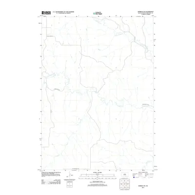
2012 Map of Herrick NE
USGS Topo · Published 2012About this map
N Fork Whetstone Cr and S Fork Whetstone Cr define the drainage patterns of this rural Gregory County landscape, where the prairie is carved by a network of seasonal and permanent watercourses. The territory is organized by a grid of township roads, including Turgeon Twp Hwy and Whetstone Twp Hwy, which facilitate travel through the agricultural heartland of South Dakota. These routes connect the open reaches between smaller tributaries like Sand Cr and Petes Cr. In the southeastern corner, Burnt Rock Cr enters the frame, highlighting the diverse creek systems that characterize this portion of the Milk's Camp Segment. The map reveals the modern infrastructure of the early 21st century, showing how Co Hwy-24 and St Charles Twp Hwy provide essential transit across the undulating terrain.
Find a feature on this map
10 named features on this map. Tap any name to fly to it.
Don’t see what you’re looking for? This feature index may not catch every label — zoom into the map to look around manually.
Map Details
Editions of this 2012 Herrick NE Map
This is the sole edition of this map. No revisions or reprints were ever made.
Other maps of this area

1955 · Mitchell
USGS Topo · 1:250,000

1959 · Mitchell
USGS Topo · 1:250,000

1964 · Herrick NW
USGS Topo · 1:24,000

1964 · Herrick NE
USGS Topo · 1:24,000

1964 · St. Charles
USGS Topo · 1:24,000

1964 · Whetstone Bay
USGS Topo · 1:24,000
1964 · Herrick
USGS Topo · 1:24,000
1964 · Bonesteel
USGS Topo · 1:24,000

1971 · Lucas
USGS Topo · 1:24,000

1971 · Lucas SE
USGS Topo · 1:24,000