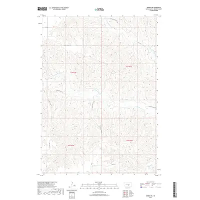
2017 Map of Herrick NE
USGS Topo · Published 2017About this map
The N Fork Whetstone Cr and S Fork Whetstone Cr dominate this section of Gregory County, carving a complex network of drainages across the landscape. The terrain is defined by these divergent watercourses, including Petes Cr, Sand Cr, and Burnt Rock Cr, which have shaped the local topography into a series of ridges and draws. This modern survey reflects a rural infrastructure built around these natural features, where township roads like the Whetstone Township Hwy and Turgeon Township Hwy follow the high ground between creek beds. The naming of local routes such as Turkey Vulcher Rd and the presence of the Old 1806 Rd suggest a long history of surface travel through this Missouri River hinterland. The map provides a clear view of the township and range system, specifically noting the intersection of t97n r70w and t96n r69w.
Find a feature on this map
19 named features on this map. Tap any name to fly to it.
Don’t see what you’re looking for? This feature index may not catch every label — zoom into the map to look around manually.
Map Details
Editions of this 2017 Herrick NE Map
This is the sole edition of this map. No revisions or reprints were ever made.
Other maps of this area

1955 · Mitchell
USGS Topo · 1:250,000

1959 · Mitchell
USGS Topo · 1:250,000

1964 · Herrick NW
USGS Topo · 1:24,000

1964 · Herrick NE
USGS Topo · 1:24,000

1964 · St. Charles
USGS Topo · 1:24,000

1964 · Whetstone Bay
USGS Topo · 1:24,000
1964 · Herrick
USGS Topo · 1:24,000
1964 · Bonesteel
USGS Topo · 1:24,000

1971 · Lucas
USGS Topo · 1:24,000

1971 · Lucas SE
USGS Topo · 1:24,000