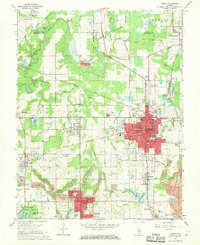
1968 Map of Herrin
USGS Topo · Published 1970About this map
The industrial coal-mining landscape of southern Illinois is deeply etched across this 1968 study, centered on the growing hub of Herrin. In this era, the region's economy is visibly tied to the Chicago Burlington and Quincy and Illinois Central railroads, which weave between numerous extractive sites like the Tailings Pond and various Mine Dumps. Smaller mining settlements such as Dewmaine, Colp, and Bush are scattered around the periphery, reflecting a decentralized worker housing pattern common to the Illinois coal fields.
Find a feature on this map
70 named features on this map. Tap any name to fly to it.
Don’t see what you’re looking for? This feature index may not catch every label — zoom into the map to look around manually.
Map Details
Editions of this 1968 Herrin Map
2 editions found
Other maps of this area

1909 · West Frankfort
USGS Topo · 1:62,500

1910 · Herrin
USGS Topo · 1:62,500

1922 · Carbondale
USGS Topo · 1:62,500

1925 · Marion
USGS Topo · 1:62,500

1936 · Herrin
USGS Topo · 1:62,500

1940 · Marion
USGS Topo · 1:62,500

1941 · Carbondale
USGS Topo · 1:62,500

1941 · West Frankfort
USGS Topo · 1:62,500

1949 · Paducah
USGS Topo · 1:250,000

1950 · Paducah
USGS Topo · 1:250,000