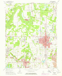
1968 Map of Herrin
USGS Topo · Published 1978About this map
Herrin serves as the industrial and civic anchor of this Southern Illinois landscape during a period of urban expansion. The 1968 survey, updated in the late 1970s, captures the growth of the coal-rich area as purple-tinted extensions reach toward Energy and Sunnyside. A network of transportation corridors, including the Illinois Central Gulf Railroad and Burlington Northern, weave through a terrain dotted with numerous Mine Dumps, reflecting the regional reliance on the mining economy.
Find a feature on this map
65 named features on this map. Tap any name to fly to it.
Don’t see what you’re looking for? This feature index may not catch every label — zoom into the map to look around manually.
Map Details
Editions of this 1968 Herrin Map
2 editions found
Other maps of this area

1909 · West Frankfort
USGS Topo · 1:62,500

1910 · Herrin
USGS Topo · 1:62,500

1922 · Carbondale
USGS Topo · 1:62,500

1925 · Marion
USGS Topo · 1:62,500

1936 · Herrin
USGS Topo · 1:62,500

1940 · Marion
USGS Topo · 1:62,500

1941 · Carbondale
USGS Topo · 1:62,500

1941 · West Frankfort
USGS Topo · 1:62,500

1949 · Paducah
USGS Topo · 1:250,000

1950 · Paducah
USGS Topo · 1:250,000