
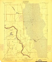
1916 Map of Hershey
USGS Topo · Published 1916About this map
Dunnigan and Hershey serve as the primary hubs of activity along the Southern Pacific (Woodland Line) in this early 20th-century survey. The landscape is defined by the agricultural and drainage patterns of the Colusa Basin, where the Colusa Co Yolo Co Boundary Line marks a transition across fertile Sacramento Valley plains. To the east, the complex hydrology of Sycamore Slough and Tule Slough reveals the natural lowlands of the basin before extensive modern water management. The mapping of Buckeye Creek and Dunnigan Creek flowing toward the rail line illustrates the geographic relationship between local water sources and the development of these small railroad towns. This survey, conducted by geographers like E.M. Douglas, captures the region's layout just as the railroad-driven economy was solidifying the importance of these roadside shipping points.
Find a feature on this map
11 named features on this map. Tap any name to fly to it.
Don’t see what you’re looking for? This feature index may not catch every label — zoom into the map to look around manually.
Map Details
Editions of this 1916 Hershey Map
This is the sole edition of this map. No revisions or reprints were ever made.
Other maps of this area

1888 · Marysville
USGS Topo · 1:125,000

1891 · Marysville
USGS Topo · 1:125,000

1894 · Marysville
USGS Topo · 1:125,000

1895 · Marysville
USGS Topo · 1:125,000

1905 · Harrington
USGS Topo · 1:24,000

1907 · Dunnigan
USGS Topo · 1:62,500

1907 · Colusa
USGS Topo · 1:62,500

1911 · Grimes
USGS Topo · 1:31,680
1912 · Tisdale Weir
USGS Topo · 1:31,680

1915 · Ronda
USGS Topo · 1:31,680