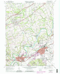
1969 Map of Hershey
USGS Topo · Published 1990About this map
The town of Hershey and the borough of Hummelstown anchor this survey of Dauphin County, showing the region as it transitioned through the late 1960s with updates into the late 1980s. The landscape is defined by the winding course of Swatara Creek and the remnants of the Union Canal, which parallels the waterway near Sand Beach. This era captures the expanding infrastructure of the chocolate capital, including the Hershey Medical Center, the State Police Academy, and the Hershey Air Park located near the Stadium.
Find a feature on this map
58 named features on this map. Tap any name to fly to it.
Don’t see what you’re looking for? This feature index may not catch every label — zoom into the map to look around manually.
Map Details
Editions of this 1969 Hershey Map
4 editions found

Other maps of this area

1892 · Hummelstown
USGS Topo · 1:62,500

1892 · Harrisburg
USGS Topo · 1:62,500

1899 · Harrisburg
USGS Topo · 1:62,500

1906 · New Cumberland
USGS Topo · 1:62,500

1908 · Middletown
USGS Topo · 1:62,500

1924 · Hummelstown
USGS Topo · 1:62,500

1924 · Harrisburg
USGS Topo · 1:62,500

1943 · New Cumberland
USGS Topo · 1:62,500

1943 · Middletown
USGS Topo · 1:62,500

1943 · Harrisburg
USGS Topo · 1:62,500
Featured Places
- Hershey, Derry Township
- Rutherford, Swatara Township
- Skyline View, West Hanover Township
- Hummelstown, PA
- East Hanover Township, PA