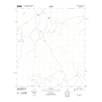
2010 Map of Hess Canyon
USGS Topo · Published 2010About this map
Old Oscar Nance Place and Old Parker Place anchor the northern reaches of this Brewster County landscape, where the geography is defined by a network of ephemeral water sources and deep drainage cuts. The presence of numerous named water catchments, such as Michigan Tank, Tin Shack Tank, and China Tank, underscores the critical importance of water management in this arid West Texas environment. These features, alongside established outposts like Willis Ranch and Old Word Ranch, suggest a long-standing ranching economy that relies on the natural topography of Hess Canyon and Javelina Canyon for livestock movement and shelter. The map traces the winding course of Burnt House Creek and Fox Canyon, providing a detailed record of land use and named landmarks in a region where family-named places and remote tanks represent the primary markers of human activity.
Find a feature on this map
23 named features on this map. Tap any name to fly to it.
Don’t see what you’re looking for? This feature index may not catch every label — zoom into the map to look around manually.
Map Details
Editions of this 2010 Hess Canyon Map
This is the sole edition of this map. No revisions or reprints were ever made.
Other maps of this area

1923 · Hess Canyon
USGS Topo · 1:62,500

1923 · Altuda
USGS Topo · 1:62,500

1929 · Hovey
USGS Topo · 1:125,000

1954 · Fort Stockton
USGS Topo · 1:250,000

1958 · Fort Stockton
USGS Topo · 1:250,000

1973 · Fort Stockton
USGS Topo · 1:250,000

1980 · Cave Mesa
USGS Topo · 1:24,000

1980 · Hovey
USGS Topo · 1:24,000
1980 · Cave Mesa SE
USGS Topo · 1:24,000
1983 · Gilliland Peak
USGS Topo · 1:24,000