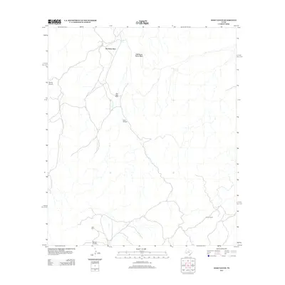
2012 Map of Hess Canyon
USGS Topo · Published 2012About this map
Hess Canyon and its surrounding drainage systems define this high-desert ranching landscape in Brewster County. The map documents a sparse network of historic land holdings, including the Old Oscar Nance Place and the Old Parker Place in the north, which sit along the intermittent flow of Burnt House Cr. The southern portion of the quadrangle transition into more varied terrain, where Willis Ranch and the Old Word Ranch are situated near the headwaters of Skinner Canyon and other deep draws. This 2012 survey illustrates the continued reliance on isolated homesteads and specific water features like Red Tank Draw in a region where geography dictates the placement of every road and structure.
Find a feature on this map
9 named features on this map. Tap any name to fly to it.
Don’t see what you’re looking for? This feature index may not catch every label — zoom into the map to look around manually.
Map Details
Editions of this 2012 Hess Canyon Map
This is the sole edition of this map. No revisions or reprints were ever made.
Other maps of this area

1923 · Hess Canyon
USGS Topo · 1:62,500

1923 · Altuda
USGS Topo · 1:62,500

1929 · Hovey
USGS Topo · 1:125,000

1954 · Fort Stockton
USGS Topo · 1:250,000

1958 · Fort Stockton
USGS Topo · 1:250,000

1973 · Fort Stockton
USGS Topo · 1:250,000

1980 · Cave Mesa
USGS Topo · 1:24,000

1980 · Hovey
USGS Topo · 1:24,000
1980 · Cave Mesa SE
USGS Topo · 1:24,000
1983 · Gilliland Peak
USGS Topo · 1:24,000