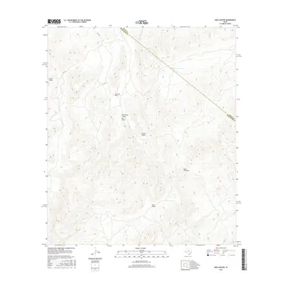
2016 Map of Hess Canyon
USGS Topo · Published 2016About this map
The Glass Mountains dominate this region of West Texas, where the high desert terrain is carved by a complex network of dry washes and named canyons. In this arid landscape, the boundary between Pecos and Brewster Counties cuts diagonally across the topography, illustrating the geometric division of the land through some of its most difficult reaches. Drainage patterns are defined by seasonal watercourses like Burnt House Creek and the Red Tank Draw, which channel runoff through Burnt House Canyon and Hess Canyon. The presence of Mills Rd in the north provides one of the few points of human access into this interior, connecting the lower elevations near Spring Canyon with the higher limestone ridges of the Glass range. Local names like Skinner Canyon suggest the historic presence of ranching families who navigated this territory long before modern surveying reached the area.
Find a feature on this map
9 named features on this map. Tap any name to fly to it.
Don’t see what you’re looking for? This feature index may not catch every label — zoom into the map to look around manually.
Map Details
Editions of this 2016 Hess Canyon Map
This is the sole edition of this map. No revisions or reprints were ever made.
Other maps of this area

1923 · Hess Canyon
USGS Topo · 1:62,500

1923 · Altuda
USGS Topo · 1:62,500

1929 · Hovey
USGS Topo · 1:125,000

1954 · Fort Stockton
USGS Topo · 1:250,000

1958 · Fort Stockton
USGS Topo · 1:250,000

1973 · Fort Stockton
USGS Topo · 1:250,000

1980 · Cave Mesa
USGS Topo · 1:24,000

1980 · Hovey
USGS Topo · 1:24,000
1980 · Cave Mesa SE
USGS Topo · 1:24,000
1983 · Gilliland Peak
USGS Topo · 1:24,000