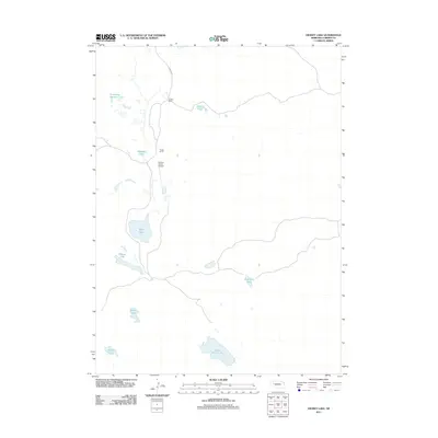
2011 Map of Hessey Lake
USGS Topo · Published 2011About this map
The isolated sandhills of Garden County define this corner of western Nebraska, where high-plains ranching and a series of wind-formed lakes create a distinct rural landscape. The area is anchored by local operations like the Young Ranch and the Pawlet Ranch, the latter of which includes the private Pawlet Ranch Airport runway along the edge of the dunes. A north-south route, Lakeside RD, provides the primary access through this sparsely populated territory, connecting the various livestock spreads.
Find a feature on this map
14 named features on this map. Tap any name to fly to it.
Don’t see what you’re looking for? This feature index may not catch every label — zoom into the map to look around manually.
Map Details
Editions of this 2011 Hessey Lake Map
This is the sole edition of this map. No revisions or reprints were ever made.
Other maps of this area

1949 · Mumper
USGS Topo · 1:62,500

1949 · Rackett
USGS Topo · 1:62,500

1950 · Crescent Lake
USGS Topo · 1:62,500

1950 · Longfellow Lake
USGS Topo · 1:62,500

1951 · Rackett
USGS Topo · 1:62,500

1954 · Scottsbluff
USGS Topo · 1:250,000

1958 · Scottsbluff
USGS Topo · 1:250,000

1985 · Crescent Lake
USGS Topo · 1:100,000
1986 · McCarty Lake
USGS Topo · 1:24,000
1986 · Hessey Lake
USGS Topo · 1:24,000