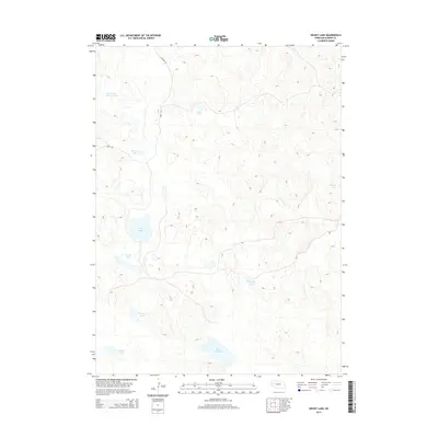
2014 Map of Hessey Lake
USGS Topo · Published 2014About this map
Hessey Lake and the surrounding alkaline basin of Garden County define this corner of the Nebraska Sandhills. The landscape is a network of ephemeral and semi-permanent water bodies, including Black Steer Lake and Wolf Lake, which sit within the depressions of a vast, undulating dune field. These lakes are critical points of reference in a terrain where traditional landmarks are sparse, connected by a few rural corridors like Lakeside Rd and Road 181. The naming conventions for features such as Mud Hole Lake and Northwest Meadow Lake reflect the practical, observational language of the ranchers who navigate this cattle country. This 2014 survey captures the hydrography of the region at a specific moment, showing how even minor catchments like Webster Lake and Shafer Lake are integrated into the larger geography of the Platte River valley watershed system.
Find a feature on this map
12 named features on this map. Tap any name to fly to it.
Don’t see what you’re looking for? This feature index may not catch every label — zoom into the map to look around manually.
Map Details
Editions of this 2014 Hessey Lake Map
This is the sole edition of this map. No revisions or reprints were ever made.
Other maps of this area

1949 · Mumper
USGS Topo · 1:62,500

1949 · Rackett
USGS Topo · 1:62,500

1950 · Crescent Lake
USGS Topo · 1:62,500

1950 · Longfellow Lake
USGS Topo · 1:62,500

1951 · Rackett
USGS Topo · 1:62,500

1954 · Scottsbluff
USGS Topo · 1:250,000

1958 · Scottsbluff
USGS Topo · 1:250,000

1985 · Crescent Lake
USGS Topo · 1:100,000
1986 · McCarty Lake
USGS Topo · 1:24,000
1986 · Hessey Lake
USGS Topo · 1:24,000