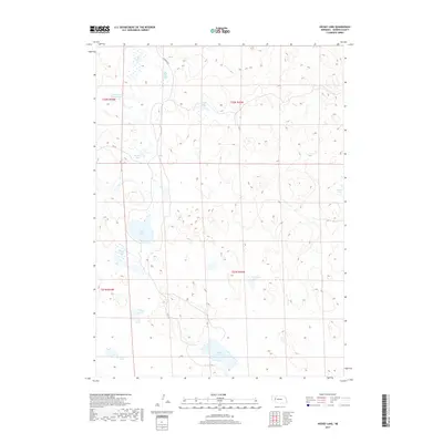
2017 Map of Hessey Lake
USGS Topo · Published 2017About this map
The Nebraska Sandhills dominate this portion of Garden County, where a unique concentration of semi-permanent alkali lakes fills the depressions between stabilized dunes. Wolf Lake and Hessey Lake serve as primary landmarks in this sparsely populated cattle country, where the landscape is defined more by its hydrology than by human settlement. Local travel is restricted to unpaved routes such as Lakeside Rd and Rd 181, which skirt the edges of marshes and basins. Notable water bodies like Black Steer Lake, Mud Hole Lake, and Webster Lake provide critical habitat and water sources in an otherwise arid environment. The map details the Township and Range system across T21N and T22N, illustrating the vast, open tracts of land typical of the region's ranching heritage in the early 21st century.
Find a feature on this map
18 named features on this map. Tap any name to fly to it.
Don’t see what you’re looking for? This feature index may not catch every label — zoom into the map to look around manually.
Map Details
Editions of this 2017 Hessey Lake Map
This is the sole edition of this map. No revisions or reprints were ever made.
Other maps of this area

1949 · Mumper
USGS Topo · 1:62,500

1949 · Rackett
USGS Topo · 1:62,500

1950 · Crescent Lake
USGS Topo · 1:62,500

1950 · Longfellow Lake
USGS Topo · 1:62,500

1951 · Rackett
USGS Topo · 1:62,500

1954 · Scottsbluff
USGS Topo · 1:250,000

1958 · Scottsbluff
USGS Topo · 1:250,000

1985 · Crescent Lake
USGS Topo · 1:100,000
1986 · McCarty Lake
USGS Topo · 1:24,000
1986 · Hessey Lake
USGS Topo · 1:24,000