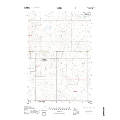
2018 Map of Hettinger South
USGS Topo · Published 2018About this map
The town of Hettinger sits at the northern edge of this landscape, positioned where the Railroad Ave corridor meets the recreational waters of Mirror Lake. Stretching south across the state line between North Dakota and South Dakota, the terrain transitions into the expansive Grand River National Grassland. This protected prairie is defined by the winding course of the North Fork Grand River and its various tributaries, including Slick Cr and Billy Young Cr. The map details a strictly organized grid of rural roads such as Ellingson Rd and Lyle Rd, which segment the rolling grasslands and ranching country. The presence of several named drainages like Bull Hook Cr and Flat Cr illustrates the watershed patterns that shaped the early settlement and grazing history of the border region between Adams County and Perkins County.
Find a feature on this map
32 named features on this map. Tap any name to fly to it.
Don’t see what you’re looking for? This feature index may not catch every label — zoom into the map to look around manually.
Map Details
Editions of this 2018 Hettinger South Map
This is the sole edition of this map. No revisions or reprints were ever made.
Other maps of this area

1953 · Dickinson
USGS Topo · 1:250,000

1954 · Lemmon
USGS Topo · 1:250,000

1957 · Dickinson
USGS Topo · 1:250,000

1957 · Lemmon
USGS Topo · 1:250,000

1974 · Hettinger North
USGS Topo · 1:24,000

1974 · Hettinger South
USGS Topo · 1:24,000

1974 · Cow Butte NE
USGS Topo · 1:24,000

1974 · Kid Rich Butte
USGS Topo · 1:24,000

1980 · Mott
USGS Topo · 1:100,000

1983 · Cow Butte SE
USGS Topo · 1:24,000