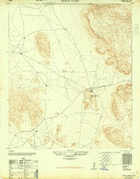
1948 Map of Heuco Tanks
USGS Topo · Published 1948About this map
Escontrias Ranch sits at the base of the Hueco Mountains in this post-war survey of the El Paso desert. This specific landscape is defined by the unique geological depressions known as Hueco Tanks, which for centuries served as vital water-storage basins for travelers in an otherwise arid basin. The map traces the historical path of the Old Butterfield Trail, marking the transition from early frontier transit to the modern surveying efforts of the Army Map Service. The network of unimproved roads and trails intersecting at the ranch suggests the area's continued role as a focal point for ranching and overland movement before the expansion of the modern highway system. Compiled from 1944 aerial photography, the sheet preserves the sparse, high-desert settlement pattern and the intricate topography of the surrounding mountain peaks.
Find a feature on this map
4 named features on this map. Tap any name to fly to it.
Don’t see what you’re looking for? This feature index may not catch every label — zoom into the map to look around manually.
Map Details
Editions of this 1948 Heuco Tanks Map
This is the sole edition of this map. No revisions or reprints were ever made.
Other maps of this area

1896 · El Paso
USGS Topo · 1:125,000

1903 · Cerro Alto
USGS Topo · 1:125,000

1908 · El Paso
USGS Topo · 1:125,000

1939 · Heuco Tanks
USGS Topo · 1:62,500

1940 · Heuco Tanks
USGS Topo · 1:62,500

1940 · Bassett Lake
USGS Topo · 1:62,500

1941 · Heuco Mountains
USGS Topo · 1:62,500

1941 · Desert
USGS Topo · 1:62,500

1943 · Desert
USGS Topo · 1:62,500

1943 · Heuco Mountains
USGS Topo · 1:62,500
Featured Places
- Hueco Mountain Estates Number 4 Colonia, TX
- Hueco Mountain Estates Number 1 Colonia, TX
- Hueco Mountain Estates Number 3 Colonia, TX
- Hueco Mountain Estates Number 7 Colonia, TX
- Hueco Mountain Estates Number 5 Colonia, TX