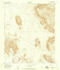
1955 Map of Heuco Tanks
USGS Topo · Published 1959About this map
The Hueco Mountains and the dramatic geological formations of the Rimrock dominate this West Texas landscape, mapped during the mid-1950s. This arid terrain in El Paso County is defined by its critical water collection points, or "tanks," which were essential for ranching and travel in the high desert. While the world-renowned Hueco Tanks are situated on the eastern edge of the sheet, the map reveals a broader network of named water sources like Jarilla Tank, Eighteen Tank, and Kerby Tank connected by an extensive system of fences. This survey, compiled from 1954 aerial photography, also records a Landing Strip (Aband) near the center of the quadrangle, suggesting the changing utility of this desert floor as the mid-century era progressed.
Find a feature on this map
15 named features on this map. Tap any name to fly to it.
Don’t see what you’re looking for? This feature index may not catch every label — zoom into the map to look around manually.
Map Details
Editions of this 1955 Heuco Tanks Map
This is the sole edition of this map. No revisions or reprints were ever made.
Other maps of this area

1896 · El Paso
USGS Topo · 1:125,000

1903 · Cerro Alto
USGS Topo · 1:125,000

1908 · El Paso
USGS Topo · 1:125,000

1939 · Heuco Tanks
USGS Topo · 1:62,500

1940 · Heuco Tanks
USGS Topo · 1:62,500

1940 · Bassett Lake
USGS Topo · 1:62,500

1941 · Heuco Mountains
USGS Topo · 1:62,500

1941 · Desert
USGS Topo · 1:62,500

1943 · Desert
USGS Topo · 1:62,500

1943 · Heuco Mountains
USGS Topo · 1:62,500
Featured Places
- Hueco Mountain Estates Number 4 Colonia, TX
- Hueco Mountain Estates Number 1 Colonia, TX
- Hueco Mountain Estates Number 3 Colonia, TX
- Hueco Mountain Estates Number 7 Colonia, TX
- Hueco Mountain Estates Number 5 Colonia, TX