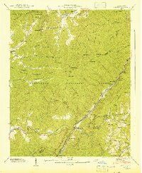
1941 Map of Hewitt
USGS Topo · Published 1941About this map
The Nantahala River carves through the heart of this landscape, flanked by the Cheoah Mountains and the Snowbird Mts. This 1941 survey documents the rugged geography of the Nantahala National Forest during a period of infrastructure expansion, most notably the Hydro-Electric Tunnel near Beechertown. Small mountain communities like Stecoah, Cody, and Nantahala are shown connected by the Southern Railway and the winding track of the Appalachian Trail. Cultural landmarks essential to local genealogy appear throughout the terrain, including Jenkins Cem, Hewitt Ch, and rural educational outposts such as Rowlin Sch and Camp Branch Sch. The presence of the Randolph Gem and Silvermine suggests the enduring mineral interests of the region, while natural features like Queens Falls and The Jump-up define the high-elevation topography.
Find a feature on this map
106 named features on this map. Tap any name to fly to it.
Don’t see what you’re looking for? This feature index may not catch every label — zoom into the map to look around manually.
Map Details
Editions of this 1941 Hewitt Map
This is the sole edition of this map. No revisions or reprints were ever made.
Other maps of this area

1933 · Bushnell
USGS Topo · 1:62,500

1935 · Robbinsville
USGS Topo · 1:24,000

1935 · Fontana
USGS Topo · 1:24,000

1935 · Burningtown Bald
USGS Topo · 1:24,000

1935 · Topton
USGS Topo · 1:24,000

1935 · Wayah Bald
USGS Topo · 1:48,000

1935 · Andrews
USGS Topo · 1:24,000

1936 · Proctor
USGS Topo · 1:24,000

1936 · Wesser
USGS Topo · 1:24,000
1936 · Hewitt
USGS Topo · 1:24,000