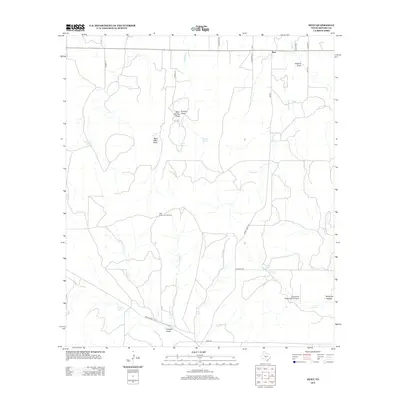
2012 Map of Hext
USGS Topo · Published 2012About this map
Hext anchors the northern boundary of this Menard County landscape, situated where FM-1221 meets the rural road network. The terrain is defined by a dense network of intermittent drainages and draws, including Twomile Cr and Fivemile Cr, which carve through the Edwards Plateau geography. Water sources were historically critical in this arid environment, as evidenced by several named springs such as McDougal Spring, Rolston Spring, and Indian Spring. To the south, the Comanche Ridge Ranch Airport and the lonely High Lonesome Windmill indicate the vast, open-range nature of the modern ranching economy. The map also traces the winding course of Leon Cr and Little Saline Cr, providing a detailed view of the natural water distribution and local topography at the start of the 21st century.
Find a feature on this map
33 named features on this map. Tap any name to fly to it.
Don’t see what you’re looking for? This feature index may not catch every label — zoom into the map to look around manually.
Map Details
Editions of this 2012 Hext Map
This is the sole edition of this map. No revisions or reprints were ever made.
Other maps of this area

1887 · Mason
USGS Topo · 1:125,000

1894 · Mason
USGS Topo · 1:125,000

1954 · Llano
USGS Topo · 1:250,000

1955 · Llano
USGS Topo · 1:250,000

1956 · Llano
USGS Topo · 1:250,000

1968 · Sheep Run Creek
USGS Topo · 1:24,000

1968 · London
USGS Topo · 1:24,000

1970 · Brewer Hollow
USGS Topo · 1:24,000
1970 · Calf Creek
USGS Topo · 1:24,000

1970 · East Elm Creek
USGS Topo · 1:24,000