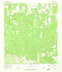
1970 Map of Hext
USGS Topo · Published 1973About this map
Hext stands as a small crossroads community on the eastern edge of Menard County at the opening of the 1970s. The landscape is defined by an intricate network of drainage draws and springs that feed into larger watercourses like Twomile Creek and Little Saline Creek. A Community Center serves the local population, while the surrounding terrain is marked by isolated water sources vital for ranching, including Mud Spring, Cistern Spring, and the uniquely named High Lonesome Windmill. The presence of numerous named springs, such as Franklin Spring and Indian Spring, underscores the critical importance of reliable water points in this portion of the Edwards Plateau. State Highway 29 provides the primary transit corridor, passing a Roadside Park and several Gravel Pits that suggest local road maintenance and small-scale surface extraction during this era.
Find a feature on this map
29 named features on this map. Tap any name to fly to it.
Don’t see what you’re looking for? This feature index may not catch every label — zoom into the map to look around manually.
Map Details
Editions of this 1970 Hext Map
This is the sole edition of this map. No revisions or reprints were ever made.
Other maps of this area

1887 · Mason
USGS Topo · 1:125,000

1894 · Mason
USGS Topo · 1:125,000

1954 · Llano
USGS Topo · 1:250,000

1955 · Llano
USGS Topo · 1:250,000

1956 · Llano
USGS Topo · 1:250,000

1968 · Sheep Run Creek
USGS Topo · 1:24,000

1968 · London
USGS Topo · 1:24,000

1970 · Brewer Hollow
USGS Topo · 1:24,000
1970 · Calf Creek
USGS Topo · 1:24,000

1970 · East Elm Creek
USGS Topo · 1:24,000