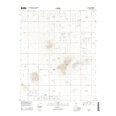
2015 Map of Hi Vista
USGS Topo · Published 2015About this map
Saddleback Butte rises as a dominant landmark in this high desert landscape, surrounded by the geometric grid of unpaved roads and rural settlements like Hi Vista and Wilsona Gardens. This 2015 snapshot of Los Angeles County's northeastern corner illustrates a transition from residential pockets in the south, such as the edge of Lake Los Angeles, to the more sparse, open terrain of the north. The topography is defined by distinctive volcanic and rock formations, including Piute Butte, Little Butte, and Long Buttes. Water drainage patterns are clearly visible through the ephemeral Big Rock Wash, which cuts across the western portion of the map. The intricate road network, labeled from E Avenue F down to E Avenue M, reveals the extensive surveying and planned development of the Antelope Valley area, even where structures remain infrequent.
Find a feature on this map
94 named features on this map. Tap any name to fly to it.
Don’t see what you’re looking for? This feature index may not catch every label — zoom into the map to look around manually.
Map Details
Editions of this 2015 Hi Vista Map
This is the sole edition of this map. No revisions or reprints were ever made.
Other maps of this area

1930 · Joshua
USGS Topo · 1:24,000

1930 · Lovejoy Springs
USGS Topo · 1:24,000

1930 · Wilsona
USGS Topo · 1:24,000

1931 · Hi Vista
USGS Topo · 1:24,000

1933 · Lovejoy Springs
USGS Topo · 1:24,000

1934 · Joshua
USGS Topo · 1:24,000

1935 · Hi Vista
USGS Topo · 1:24,000
1935 · Wilsona
USGS Topo · 1:24,000

1937 · Shadow Mountains
USGS Topo · 1:48,000

1937 · Kramer
USGS Topo · 1:48,000