
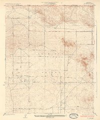
1935 Map of Hi Vista
USGS Topo · Published 1935About this map
Antelope Valley defines the expansive landscape of this 1930s survey, where a rigid grid of numbered avenues begins to impose order on the high desert floor. The small settlement of Hi Vista sits along Avenue G, serving as a focal point for local activity near the southern reaches of the quadrangle. To the northwest, the prominent rising terrain of Mt Mesa provides a distinctive landmark, notable for being the site of the Mt Mesa Sanitarium. The map documents the boundary between Kern County and Los Angeles County, illustrating a period when this remote area was characterized by wide-open spaces and the early development of a systematic road network, including thoroughfares like Avenue A 8 and Avenue B.
Find a feature on this map
17 named features on this map. Tap any name to fly to it.
Don’t see what you’re looking for? This feature index may not catch every label — zoom into the map to look around manually.
Map Details
Editions of this 1935 Hi Vista Map
2 editions found
Other maps of this area

1930 · Joshua
USGS Topo · 1:24,000

1930 · Lovejoy Springs
USGS Topo · 1:24,000

1930 · El Mirage
USGS Topo · 1:24,000

1930 · Wilsona
USGS Topo · 1:24,000

1931 · Adobe
USGS Topo · 1:24,000

1931 · Hi Vista
USGS Topo · 1:24,000

1933 · Lovejoy Springs
USGS Topo · 1:24,000

1933 · El Mirage
USGS Topo · 1:24,000

1934 · Joshua
USGS Topo · 1:24,000

1934 · Adobe
USGS Topo · 1:24,000