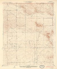
1935 Map of Hi Vista
USGS Topo · Published 1935About this map
Antelope Valley spreads across the high desert floor in this 1930s survey, showing a strictly gridded landscape of lettered roads that intersect the arid terrain north of the San Gabriel Mountains. The primary settlement of Hi Vista serves as the focal point for this rural corner of Los Angeles County, situated near the boundary with Kern Co Los Angeles Co. The topography is marked by isolated elevations like Mt Mesa, which rises abruptly from the flat valley floor.
Find a feature on this map
16 named features on this map. Tap any name to fly to it.
Don’t see what you’re looking for? This feature index may not catch every label — zoom into the map to look around manually.
Map Details
Editions of this 1935 Hi Vista Map
2 editions found

Other maps of this area

1930 · Joshua
USGS Topo · 1:24,000

1930 · Lovejoy Springs
USGS Topo · 1:24,000

1930 · El Mirage
USGS Topo · 1:24,000

1930 · Wilsona
USGS Topo · 1:24,000

1931 · Adobe
USGS Topo · 1:24,000

1931 · Hi Vista
USGS Topo · 1:24,000

1933 · Lovejoy Springs
USGS Topo · 1:24,000

1933 · El Mirage
USGS Topo · 1:24,000

1934 · Joshua
USGS Topo · 1:24,000

1934 · Adobe
USGS Topo · 1:24,000