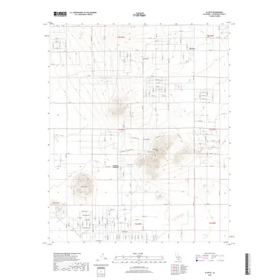
2018 Map of Hi Vista
USGS Topo · Published 2018About this map
Saddleback Butte rises as a prominent landmark in this desert landscape within Los Angeles County, anchoring a terrain defined by isolated volcanic peaks. The small community of Hi Vista sits in the northeastern reaches of the quadrangle, while Wilsona Gardens is situated further west. This area shows a transition from sparse residential settlement to open basin floor, characterized by a strictly rectilinear grid of modern county roads like E Ave J 8 and Valeport Ave. Beyond the residential clusters, the geography is shaped by the ephemeral drainage of Big Rock Wash and several distinct geological features including Piute Butte, Little Butte, and the Rocky Buttes. The placement of these buttes suggests a landscape where high-ground relief provided critical orientation for early travelers across the Antelope Valley floor.
Find a feature on this map
56 named features on this map. Tap any name to fly to it.
Don’t see what you’re looking for? This feature index may not catch every label — zoom into the map to look around manually.
Map Details
Editions of this 2018 Hi Vista Map
This is the sole edition of this map. No revisions or reprints were ever made.
Other maps of this area

1930 · Joshua
USGS Topo · 1:24,000

1930 · Lovejoy Springs
USGS Topo · 1:24,000

1930 · Wilsona
USGS Topo · 1:24,000

1931 · Hi Vista
USGS Topo · 1:24,000

1933 · Lovejoy Springs
USGS Topo · 1:24,000

1934 · Joshua
USGS Topo · 1:24,000

1935 · Hi Vista
USGS Topo · 1:24,000
1935 · Wilsona
USGS Topo · 1:24,000

1937 · Shadow Mountains
USGS Topo · 1:48,000

1937 · Kramer
USGS Topo · 1:48,000