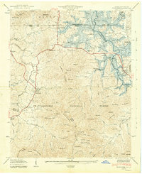
1942 Map of Hiawassee
USGS Topo · Published 1942About this map
The Hiwassee River valley and its surrounding ridges dominate this 1942 landscape, capturing the area during the initial filling of the Chatuge Reservoir. Blue shaded areas indicate the lands intended for submergence as the Tennessee Valley Authority transformed the river geography. Significant local centers like Young Harris and the county seat of Hiawassee are shown alongside smaller rural communities such as Jacksonville and Friendship. The map records a dense network of mountain schools and churches, including Brasstown Sch, Hog Creek Sch, and Old Union Ch, which served these high-country settlements before many were impacted by the new reservoir levels. From the agricultural bottoms of Brasstown Creek to the high peaks of Cedarcliff Mountain and Wolfpen Ridge, the map documents the transition of Towns County into the hydroelectric era within the Chattahoochee National Forest.
Find a feature on this map
87 named features on this map. Tap any name to fly to it.
Don’t see what you’re looking for? This feature index may not catch every label — zoom into the map to look around manually.
Map Details
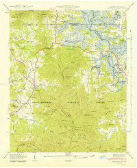
Editions of this 1942 Hiawassee Map
2 editions found
Other maps of this area

1886 · Dahlonega
USGS Topo · 1:125,000

1892 · Dahlonega
USGS Topo · 1:125,000

1896 · Dahlonega
USGS Topo · 1:125,000

1903 · Dahlonega
USGS Topo · 1:125,000

1935 · Coosa Bald
USGS Topo · 1:24,000

1935 · Peachtree
USGS Topo · 1:24,000

1935 · Osborn
USGS Topo · 1:24,000

1935 · Shooting Creek
USGS Topo · 1:24,000

1935 · Wayah Bald
USGS Topo · 1:48,000

1935 · Tray Mountain
USGS Topo · 1:24,000