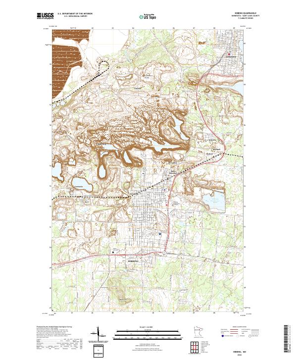
2022 Map of Hibbing
USGS Topo · Published 2022About this map
The Mesabi Range forms the industrial and geographical backbone of this northern Minnesota landscape, where the iron mining legacy is written into the very footprint of the earth. The town of Hibbing dominates the southern half of the map, showing a dense urban grid that transitions into specialized mining areas like Scranton and the Kerr Location. Notable local landmarks include the Saint Louis County Courthouse and Hibbing Community College, while the North Hibbing Cem and Maple Hill Cem provide essential anchor points for genealogists. To the north, the terrain rises toward the Laurentian Divide, passing through smaller settlements such as Brooklyn, Ruby Junction, and Kitzville before reaching Chisholm. The map captures a landscape defined by significant water management features, such as the Whitney Clearwater Basin, which reflect the massive environmental engineering required by the region's taconite industry.
Find a feature on this map
83 named features on this map. Tap any name to fly to it.
Don’t see what you’re looking for? This feature index may not catch every label — zoom into the map to look around manually.
Map Details
Editions of this 2022 Hibbing Map
This is the sole edition of this map. No revisions or reprints were ever made.
Historical Maps of Kitzville Through Time
8 maps found