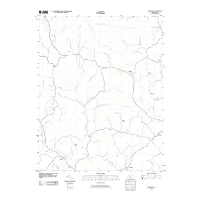
2010 Map of Hibernia
USGS Topo · Published 2010About this map
The community of Hibernia serves as a central point in this part of Taylor County, where the landscape is defined by the branching tributaries of the Green River watershed. Numerous family-named burial grounds, such as Dewitt Cemetery, Underwood Cemetery, and Skaggs Cemetery, are scattered across the terrain, offering a clear map of the area's genealogical footprint. The road network follows the ridges and valleys carved by Big Brush Creek and the various forks of Otter Creek, including West Fork Otter Creek and Middle Fork Otter Creek.
Find a feature on this map
54 named features on this map. Tap any name to fly to it.
Don’t see what you’re looking for? This feature index may not catch every label — zoom into the map to look around manually.
Map Details
Editions of this 2010 Hibernia Map
This is the sole edition of this map. No revisions or reprints were ever made.
Other maps of this area

1953 · Howardstown
USGS Topo · 1:24,000

1953 · Saloma
USGS Topo · 1:24,000

1953 · Hudgins
USGS Topo · 1:24,000

1953 · Hibernia
USGS Topo · 1:24,000

1953 · Summersville
USGS Topo · 1:24,000

1953 · Magnolia
USGS Topo · 1:24,000
1953 · Hodgenville
USGS Topo · 1:24,000

1953 · Raywick
USGS Topo · 1:24,000

1954 · Greensburg
USGS Topo · 1:24,000

1957 · Winchester
USGS Topo · 1:250,000