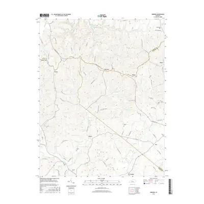
2016 Map of Hibernia
USGS Topo · Published 2016About this map
Hibernia and Bloyd anchor this landscape where LaRue, Taylor, and Green counties meet. The terrain is defined by the headwaters of the Otter Creek system to the north and the Brush Creek watershed to the south, separated by high ground like Muldraugh Hill and Bloyds Bluff. The settlement pattern follows ridge-top roads such as Campbellsville Rd and Hodgenville Rd, connecting small communities like Badger and Mac. This area is particularly rich in family burial grounds, offering significant genealogical value through the mapping of the Dewitt Cem, Skaggs Cem, and Walker Cem. The rural character is underscored by the dense network of local routes like Hibernia Ridge Rd and Black Snake Creek Rd, which provide access to the various forks and branches that carve through the central Kentucky hills.
Find a feature on this map
81 named features on this map. Tap any name to fly to it.
Don’t see what you’re looking for? This feature index may not catch every label — zoom into the map to look around manually.
Map Details
Editions of this 2016 Hibernia Map
This is the sole edition of this map. No revisions or reprints were ever made.
Other maps of this area

1953 · Howardstown
USGS Topo · 1:24,000

1953 · Saloma
USGS Topo · 1:24,000

1953 · Hudgins
USGS Topo · 1:24,000

1953 · Hibernia
USGS Topo · 1:24,000

1953 · Summersville
USGS Topo · 1:24,000

1953 · Magnolia
USGS Topo · 1:24,000
1953 · Hodgenville
USGS Topo · 1:24,000

1953 · Raywick
USGS Topo · 1:24,000

1954 · Greensburg
USGS Topo · 1:24,000

1957 · Winchester
USGS Topo · 1:250,000