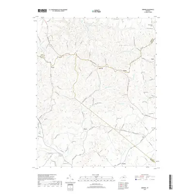
2019 Map of Hibernia
USGS Topo · Published 2019About this map
Hibernia and the surrounding rural uplands of the Green River watershed are depicted in this recent survey, where the convergence of Taylor, Green, and LaRue counties creates a complex network of ridgeline roads and creek valleys. The landscape is defined by the headwaters of Big Brush Cr and Otter Cr, which carve through the terrain south of the prominent Muldraugh Hill rise. Settlement patterns follow the high ground, with small communities like Wards, Badger, and Maple linked by historic thoroughfares such as Campbellsville Rd and Hodgenville Rd.
Find a feature on this map
91 named features on this map. Tap any name to fly to it.
Don’t see what you’re looking for? This feature index may not catch every label — zoom into the map to look around manually.
Map Details
Editions of this 2019 Hibernia Map
This is the sole edition of this map. No revisions or reprints were ever made.
Other maps of this area

1953 · Howardstown
USGS Topo · 1:24,000

1953 · Saloma
USGS Topo · 1:24,000

1953 · Hudgins
USGS Topo · 1:24,000

1953 · Hibernia
USGS Topo · 1:24,000

1953 · Summersville
USGS Topo · 1:24,000

1953 · Magnolia
USGS Topo · 1:24,000
1953 · Hodgenville
USGS Topo · 1:24,000

1953 · Raywick
USGS Topo · 1:24,000

1954 · Greensburg
USGS Topo · 1:24,000

1957 · Winchester
USGS Topo · 1:250,000