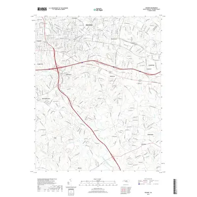
2019 Map of Hickory
USGS Topo · Published 2019About this map
The Hickory area at the close of the 2010s reveals a complex urban and suburban landscape defined by the confluence of the Henry Fork and Jacob Fork rivers as they form the South-Fork Catawba River. Modern infrastructure, including the dense grid of northwest and southwest streets in the city center, contrasts with the peripheral communities of Mountain View and Brookford. Local history is anchored by several long-standing cemeteries such as Oakwood Cem and Old Robinson Cem, while the industrial and logistics character of the region is supported by Wilson's Airport to the south. The terrain is crisscrossed by numerous small water bodies like Lyle Cr and Clark Cr, which dictated the early placement of mills and subsequent residential expansion toward Conover and Newton.
Find a feature on this map
291 named features on this map. Tap any name to fly to it.
Don’t see what you’re looking for? This feature index may not catch every label — zoom into the map to look around manually.
Map Details
Editions of this 2019 Hickory Map
This is the sole edition of this map. No revisions or reprints were ever made.
Other maps of this area

1895 · Hickory
USGS Topo · 1:125,000

1953 · Charlotte
USGS Topo · 1:250,000

1954 · Charlotte
USGS Topo · 1:250,000

1960 · Charlotte
USGS Topo · 1:250,000

1962 · Charlotte
USGS Topo · 1:250,000
1970 · Banoak
USGS Topo · 1:24,000
1970 · Maiden
USGS Topo · 1:24,000

1970 · Bethlehem
USGS Topo · 1:24,000

1970 · Newton
USGS Topo · 1:24,000
1970 · Granite Falls
USGS Topo · 1:24,000